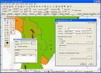
CANVAS 9 GIS Mapping Edition includes direct support for Geographic Information System data. You can take measurements in geographic coordinates, import SHAPE & GeoTIFF files into unlimited numbers of automatically aligned overlapping layers.
The CANVAS 9 GIS Mapping Edition adds native support for Geographic Information System (GIS) data to Canvas. You can take measurements in geographic coordinates, import industry standard SHAPE and GeoTIFF files into unlimited numbers of automatically aligned overlapping layers and choose among the following options:
2,104 Coordinate Reference Systems
67 Operation Methods (like Mercator, Albers Conic Equal Area�)
1,052 Map Projections
302 Geodetic Datums
21 Angular units
45 Length units
The CANVAS 9 GIS Mapping Edition bridges the gap between dedicated GIS analysis software and generic "DTP" software. For many applications CANVAS 9 GIS Mapping Edition can now replace programs costing thousands. For the rest, CANVAS 9 GIS Mapping Edition is now the preferred "last mile" publishing companion to dedicated GIS analysis software. Whats new in version 9.0.4: GIS specific features are now available via a top-level menu. Importing SHP files streamlined & Improved Requirements: PowerPC, Mac OS X, 128 MB RAM 100 MB HD, 16-bit graphics, 1024 x 768 res Operating system: Mac PPC Release notes: Minor Update
Vi3Dim have developed a new 3D capture system that could revolutionize the way in which 3D models of real-world objects are created.We have created a program able to build 3D models of textured objects , using only a standard computer and webcam.
Price: $0, Rating: 10, Downloads: 139 Download
A compact Free AutoCAD viewer. It is designed to be easy to use for the non-CAD user.It supports dwg & dxf formats.
Price: $0, Rating: 0, Downloads: 126 Download
X-Camme e' un add-in per Excel per la progettazione e la realizzazione di meccanismi a camma e intermittori.
Camme piane, a disco, lineari, cilindriche, globoidali, meccanismo biella manovella, camme a lobi
Price: $0, Rating: 10, Downloads: 113 Download
plot2k is AutoCAD Batch Plot Utility which can open and print AutoCAD drawings in Batch mode. Plot2k is a 32 bit utility designed to open and print AutoCAD drawings in batch mode.
Price: $39.95, Rating: 10, Downloads: 108 Download
User Rating
Rating:0.0 out of
5 Based on0 ratings.
0 user reviews.

 9.0.4.png)