TOPOWIN is a state-wide register of the German topographic cartographies and of localities with geo references in different coordinate systems. It also is a topographic information system.
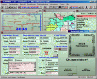
TOPOWIN is a state-wide register of the German Topographic Cartographies, the German Basic Cartography and of localities with geo references in different coordinate systems. It is also a topographic information system. In the division of planning and execution of economical and scientific projects frequently topographic documents are used. The program TOPOWIN makes information available of the official topographic cartographies and the German Basic Cartography from the entire national territory in suitable graphic views. It accomplishes different coordinate transformations and inquiries. The program was developed under co-operation of the land surveying authorities of many German Federal States. For the first time in the previous version TOPO (for DOS) and later in TOPOWIN state-wide topographic information were arranged for the data technical evaluation. The program is for consulting engineers, planning authorities and users of topographic maps a useful and versatile tool. The topographical maps of different standards, required for a project, can be determined by the entering of known parameters or by the direct selection from overview graphics and from sorted lists. By the investigation of topographical records on the basis of known places, a data base with more then 105.000 places and residential districts is available. The program TOPOWIN calculates with Gauss Krueger coordinates and Geographic Coordinates refering to the Potsdam Datum (Bessel ellipsoid with central point Rauenberg). It also works with UTM coordinates and UTMRef coordinates in the NATO standard, which refer to the datum ETRS89 (GRS80 / WGS84, geocentric).
Whats new in version 11.21: Genauere Koordinatentransformationen mit neuer GeoDLL. Datenstand auf den 5. Sept. 2011 aktualisiert (Kreis-Gebietsreform in Mecklenburg-Vorpommern). WIN-Vista und WIN-7 Zertifizierung erneuert. Programm mit modernem CHM-Hilfesystem ausgestattet. Um 3500 Ortsteile auf ca. 119000 Datens�tze erg�nzt. Requirements: 500 MHz, 500 MB Memory, 100 MB HD Operating system: Win2000,Win7 x32,Win7 x64,Win98,WinMobile,WinOther,WinServer,WinVista,WinVista x64,WinXP Release notes: Major Update
MSSQL to MySQL database converter software converts MSSQL database, even tables are stored at new location or overwrite the existing MySQL database. MSSQL to MySQL table migration utility converts table and stores that database at specified location.
Price: $45, Rating: 8.33, Downloads: 195 Download
Do you have such kind experience that you can not view the complete SQL Script because of the reason with "WITH ENCRYPTION" when you view the Stored Procedure, View, Trigger and Function of MS SQL SERVER? If yes, the DecrypSQL can help you.
Price: $79.95, Rating: 9, Downloads: 148 Download