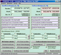
TRANSDAT Coordinate Conversion supports thousands of coordinate systems and geodetic datum shifts, user-defined systems, INSPIRE, NTv2, BeTA2007, GPS, continental drift, many file systems, ESRI-Shape and much more with highest accuracy.
TRANSDAT Geosoftware executes coordinate transformations and geodetic datum shifts between many coordinate and reference systems of America, Australasia, Europe, Germany special and world-wide, at high precision and high speed: 1.The current and historical coordinate and reference systems of all countries of the European Union (EU) including the eastern extensions and the systems of non-EU countries. 2. The INSPIRE supported European ETRS89 systems. 3. The US and Canadian State Plane Coordinate Systems (SPCS) on NAD27 and NAD83 and other coordinate systems of the North American continent. 4. The coordinate and reference systems of the Australasian continent. 5. Many coordinate and reference systems of the countries of other continents. 6. World-wide NTv2 grid file supported coordinate transformations. 7. All global coordinate and reference systems. 8. The German coordinate and reference systems of the old and new federal states, the 40 Prussian Soldner Land Registers, the German Lagestatus, and exact reference systems of the German federal states. You will find a complete list of the coordinate and reference systems supported by the program on the internet or after downloading the free test version of the program. The NTv2 standard with national grid files is world-wide full supported. Apart from the given world-wide and state-specific systems, your own personal coordinate systems and geodetic reference systems can be defined with Helmert (Bursa / Wolf, ISO19111) or Molodenski parameters. Calculations can be performed with coordinates entered directly, loaded from files in various formats (Text, CSV, SDF, dBase, ArcShape and ArcGenerate), or passed via batch processing. ArcShape files can be viewed with the program-internal Shape Viewer. A programmable GPS interface makes it possible to read coordinates into a notebook computer from a low-cost GPS antenna. The program can be run on a network, in which case clients are installed automatically.
Whats new in version 14.41: Neue CRS von Australien. Anzeige von Koordinaten in GoogleMaps und GoogleEarth. Ausgabe von Fensterinhalten in GIF/BMP-Dateien. Neues CRS Lagestatus 100 DHDN Hessen ab Dez. 2007. Unterst�tzt das CSV-Format. Neue Sprachen Griechisch, Franz�sisch, Portugisisch. Unterst�tzt INSPIRE, NTv2, BeTA2007. Requirements: 500 MHz, 500 MB Memory, 100 MB HD Operating system: Win2000,Win7 x32,Win7 x64,Win98,WinMobile,WinOther,WinServer,WinVista,WinVista x64,WinXP Release notes: Major Update
MIETrak ERP Software is a fully integrated business software solution. Modules include Quoting, Order Entry, Purchasing, Scheduling, Data Collection, Routing, Work Orders, Accounting, Quickbooks Integration, Inventory Control, BOM's, Invoicing, etc.
Price: $2000, Rating: 6, Downloads: 165 Download
Online Radio Bar for FireFox - enjoy online radio & TV.
* for Windows, Linux, MacOS
* direct access to best RS search engines
* torrent search
* internet radio
* internet TV
* RSS feeds - news, soft, games
* email notif
Price: $0.00, Rating: 10, Downloads: 152 Download
This is the top of the line of the AnyOrder Professional Series. Designed for web or mail order businesses, it prepares invoices, does billings, tracks inventory, handles barcodes, processes on-line shipments, creates purchase orders & more.
Price: $489.00, Rating: 8, Downloads: 148 Download
User Rating
Rating:2.2 out of
5 Based on13 ratings.
13 user reviews.

 14.41.png)